Popular Posts

Wednesday, November 19, 2014

OVERVIEW of VIKING WATERWAY


The copper haulers may have worked on a three year cycle.  The goal for the first year was to sail from from Norway to the Nelson River in time to launch the rowboats so they could reach Stakke Lake.  Ships timed the voyage to arrive at Hudson Strait when the ice was thawed.  At the Nelson river, the boatmen began the race agains temperature to reach Stakke Lake before the river waters froze.  In the spring the boatmen launched from Stakke lake. They rowed to Minneapolis to pick up 5 tons of pure copper.  Then they rowed down stream to the Yucatan to over winter there until the Atlantic hurricane season was over.  The three year cycle coincides with the voyages of Hiram and Solomon in the Bible.


Add caption
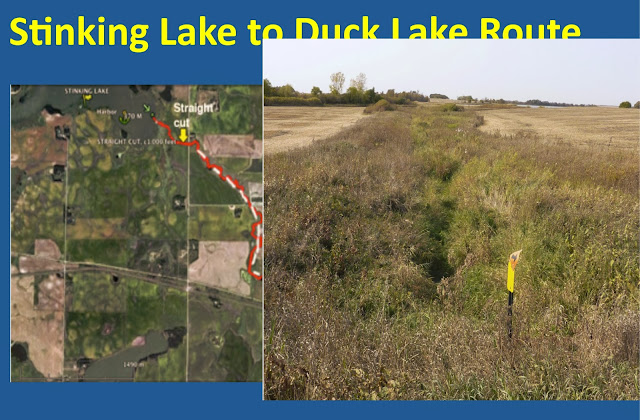
The boat route from Stinking Lake to Duck Lake is shown by the red-white trace on the left.  The view of the straight cut  is shown on the right.  This straight channel may have been an attempt by men to extent a channeled waterway through a marshy area.  The two hillocks in the distance appear to be created by man for some purpose.
Add caption
Add caption


Then the boats had to be lifted 62 feet up this ramp.  Men with ropes standing above the boats may have helped to lift the boats that weighed up to a ton.  The ramp is on the right.  The Harbor at Duck Lake is on the left and shown in an overview at bottom right.  Note the man-modified berms extending from both shores and the symmetry of a harbor that could hold up to 150 boars.  Duck Lake may have been a temporary collection harbor as the boats were portaged to Stakke Lake.

The boat portage from Duck Lake to Stake Lake is a portage that requires gaining more than 60 more feet and moving the boats overland 4.1 miles.  There is evidence that an attempt was made to create a lake, which is shown as Park Lake, but the success of a man-made lake with no inflow is doubtful.  However they portaged the boats, getting to Stakke Lake appears to be the best route for the boatmen.


Add caption

The Jetty at Stakke Lake was the intermediate destination for the boatmen.  The hundreds of boats were strung out along the Red River and Buffalo River.  Food had been stored at Stakke Lake by the hunters during the summer.  Groups of boats would arrive at the Jetty.  They would raise the boats onto their oars to make living space.  They would rest and restore their energies until the spring thaw.  Then they would launch the boats with the intention to row to Minneapolis to pick up copper and float down the Mississippi.  An older jetty can be seen above the line of trees in the upper left of the picture.  When the lake elevation was raised to 1380 ft the older jetty was flooded.  The existence of two jetties in Stakke Lake is strong evidence that jetties were in use for many centuries.


The Jetty at Stakke Lake appears to be man-modified because the terrain contours of the Jetty are parallel for more than a 1,000 ft, the contours turn ninety degrees to make a 450 foot jetty.  The elevation of the Jetty is more than 1380 feet.  That elevation appears to be the height of the the dam at Middle and Big Cormorant Lake.  The Jetty may have been deliberately built at an angle so men, who were strangers to the area could identify the correct lake.  The Jetty also appears to have been deliberately built to create a secure harbor.  The fact that Stakke Lake has an older jetty almost cinches the hypothesis that the Jetty at Stakke Lake was man-made.


http://myronpaine.blogspot.com/2018/01/american-history-organization-update-9.html

The facts that the bus driver recognized the more ancient jetty and that Mark Hilde was able to guide the bus to a probable ancient gathering spot, means that the Viking Waterway tour was telling a plausible, but incomplete, story and that tour was following the correct route.

The VIKING WATERWAY TOUR BOOKLET is at FROZEN TRAIL to MERICA.


No comments:

Post a Comment